Written by Robert Gay and reprinted by permission of the Patagonia Regional Times
The various trails in and around Patagonia have been given some love recently by several organizations, often aided by residents. Here’s a look at what’s been happening on the trails, and what may be coming in the future.
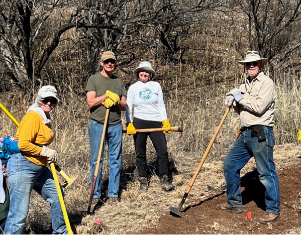
Members of the Dirtbags volunteer trail work group take a break for a photo. “We don’t work fast, but we sure work cheap!” quipped one Dirtbagger.
The Nature Conservancy
The Nature Conservancy (TNC)’s Geoffrey Platts Trail received a big dose of care this spring from a visiting group of roughly 100 Arizona Conservation Corps (AZCC) members. Coordinating with TNC’s PatagoniaSonoita Creek Preserve manager Aaron Mrotek, the Conservation Corps members have also worked on small trail rerouting projects, invasive species removal, and clearing for the Cemetery Trail. They report loving the work and education, and that AZCC will be back again this winter.
In other trails-related work by TNC, Mrotek reports that new trail mapping and signage has been designed and will be installed this fall at the preserve. Mrotek uses signage and the trails themselves to gently guide visitors without inadvertently encouraging foot traffic everywhere. Because it’s a preserve, the goal of the TNC trail system is to get people into nature, but not onto every square yard of it.
Sometimes arriving at a good viewpoint is enough, and strategic bench placement is part of many local trails. TNC’s maintenance of the Cemetery Trail was also aided this year by the Borderlands Earth Care Youth (BECY) group. BECY members began with an assessment of plants and wildlife they observed along the trail, since a core piece of their project-based ecological learning is wildlife awareness. Further work on the Cemetery Trail by the end of this year will reroute the climb from the flat portion up to the Cemetery fence. The new alignment will fix unduly steep steps and control erosion.
The Dirtbags
Patagonia’s Dirtbag group works all over the region. This year, they’ve exercised trail skills in the Wildlife Corridors network, including building a new half-mile loop called The Discovery Trail. Longtime Dirtbagger John Hughes reports that the team has also been working on two Patagonia Lake area trails, doing vegetation removal and erosion responses. Still other Dirtbagger projects included the Paul Baird Trail connecting the Paton Center to the Geoffrey Platts trail, and firewise clearing of undergrowth for the TNC property bordering Costello Street. Hughes reported that the group has been very busy over the past year and that a strong monsoon season this summer could produce another large vegetation year. The “baggers” welcome volunteers. Contact Hughes at his email address.
Harshaw Rd.
Since the realignment of the Arizona Trail (AZT), Harshaw Rd. sees far fewer hikers. Still, for gravel bikers, Harshaw Rd. remains a gateway to many trails in Patagonia Mountains and the San Rafael Valley.
Where Harshaw Road encounters the Hermosa Project, South32 has installed a half-mile detour. The detour climbs the mine site’s main entry road toward a guardhouse at the ridge the project straddles, then drops back to Harshaw Rd. The detour includes a bike lane and is planned to last until October. South32 has declined to state their reasons for closing the road, but they do have the full cooperation of the County.
Train Track Trail
Running parallel to SR 82 out of Patagonia toward Sonoita, the Train Track Trail (TTT) saw lots of bushy vegetation crowding the path this spring. Tomás Jonsson of the Mountain Empire Trail Association (META) explained that the volunteer weed-whackers and branch-trimmers had to keep at it, since it’s a connection between “downtown” and the new AZT trailhead at Casa Blanca Canyon. META will be enhancing signage at the trailhead to direct AZT hikers toward Patagonia via the TTT instead of the shoulders of SR 82, where some hikers have been seen hitchhiking in or out of town.
For years in Patagonia, trailmakers like META have explored the idea of extending the TTT to Sonoita. Last fall, when Valley Telecom buried a fiber optics cable from Sonoita to Patagonia Union High School, trailmakers saw the miles of disturbed ground as a natural opportunity for TTT extension along SR82. Much of its route could follow the historical railroad bed, but the obstacle to building it is the unwillingness of the AZ Department of Transportation to grant foot-trail use within the State Route 82 right-of-way.
META member German Quiroga sees a possible way around this roadblock: “We need to develop a plan that we can take to the county and get the county to apply for a permit with the state, and we need to get support from our state legislators for the project,” he said.
Yet another obstacle in railroad trail connectivity is the intersection planned for South32’s Cross-Creek Connector Road and SR 82. If a collaborative design solution can’t be worked out with the County, the TTT will be broken. AZT hikers, bikers and riders who bring business to the town, will either give up or will have to use a much less safe highway connection.
The most ambitious vision for railroad trail connectivity would also include a leg south from Patagonia. The segment below Patagonia Lake could follow Sonoita Creek to the DeAnza Trail at Rio Rico. Friends of Sonoita Creek president Bob Proctor called it “a dream in the making,” but added that “the Baca Float rezoning may quash the dream.”
Detailed trail info can be found on a sign near the Patagonia Visitor Center in Doc Mock Park at the gazebo, giving details and distances about many trails near the town. A paper trailhead map gives directions to trailheads and parking areas for local trails. The map is available at the Visitor Center and at the Patagonia Town Hall. A trail map for the Borderlands Wildlife Preserve is available at borderlandswildlifepreserve.org